[Plano que representa el paseo maritimo de la muralla sur...


 Maps, plans and nautical charts
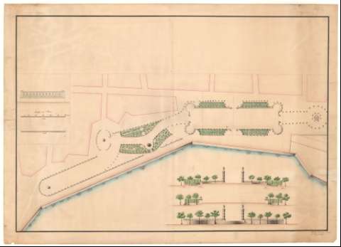
[Plano que representa el paseo maritimo de la muralla sur de Cádiz] (18--)
Maps, plans and nautical charts
[Plano que representa el paseo maritimo de la muralla sur de Cádiz] (18--)
 Disponible Holdings
 Section: Maps, plans and nautical charts
Uniform title: CÁDIZ. Parques públicos. 1:120 y 1:360 (18)
Title: [Plano que representa el paseo maritimo de la muralla sur de Cádiz] / Mateo Hurtado lo proyctó y dibujó
Material or type of resouce Area: Escala 1:120 y 360
Publication: [18--]
Physical description: 1 plano : ms., col. ; 72'4 x 101'1 cm
Content type: Imagen cartográfica
Media type: computadora
Carrier type: recurso en línea
Notes: Presenta 1 planta y 2 vistas
Título facticio
Manuscrito firmado. A plumilla en tinta negra y roja, iluminado a la acuarela en carmín, verde, gris, amarillo y azul
Reproducción digital. Madrid : Ministerio de Defensa. Archivo General Militar de Madrid
Other authors: Hurtado, Mateo
UDC: (460.355 Cádiz)
Type of publication:
Maps
Rights:
Préstamo:
Disponible
