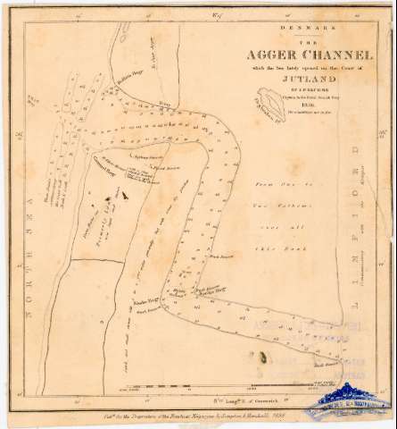
The Agger Channel which the Sea lately opened on the...


 Maps, plans and nautical charts
The Agger Channel which the Sea lately opened on the Coast of Jutland (1838)
Maps, plans and nautical charts
The Agger Channel which the Sea lately opened on the Coast of Jutland (1838)
 Disponible Holdings
 Section: Maps, plans and nautical charts
Title: The Agger Channel which the Sea lately opened on the Coast of Jutland / by I.P. Bluhme Captain in the Royal Danish Navy
Material or type of resouce Area: Escala [ca. 1:40000], 1 Nautic Mile [= 6 cm] (E8°19'-E8°15'/N56°49'-N56°43')
Publication, Production, Distribution, etc.: Publicación: [London] : Pubd. for the Proprietors of the Nautical Magazine by Simpkin & Marshall, 1838
Fabricación: [London] : Day & Haghe Litho. to the Queen, [1838]
Physical description: 1 carta naútica : montado sobre tela ; 20,5x18,1 cm
Content type: Imagen cartográfica
Media type: computadora
Carrier type: recurso en línea
Notes: Recuadro geográfico de 5' en 5'
Indica veriles, bancos, fondeaderos y sondas batimétricas expresadas en pies
Procede de la 'Colección Rico y Sinobas'
Other authors: Bluhme, I.P
Simpkin & Marshall (Londres)
Day & Haghe
UDC: 912:551.46]:[626.1](489 Jutlandia, península)'1836'
489 Jutlandia, península
Type of publication:
Maps
Rights:
Préstamo:
Disponible
