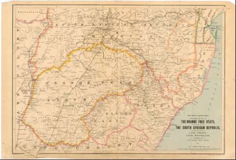
Stanford's new map of the Orange free state, the southern...
Section: Maps, plans and nautical charts
Uniform title: AFRICA. SE. Mapas generales. 1:1000000 (1899)
Title: Stanford's new map of the Orange free state, the southern part of the south African Republic, the northern frontier of Cape Colony, Natal, Basutoland, and Delagoa Bay in Portuguese East Africa : the Crisis in South Africa / Stanford's Geographical Establishment...
Material or type of resouce Area: 1:1000000 ; [proyec. sinusoidal]
Publication: London : Published by Edward Stanford, 26 & 27, Cock spur Street, Charing Cross, S.W., 1899
Physical description: 1 mapa : col. ; 68,5 x 101,2 cm
Content type: Imagen cartográfica
Media type: computadora
Carrier type: recurso en línea
Notes: Comprende Swazilandia, Lesotho y parte de Mozambique y Sudáfrica
Coordenadas según el meridiano de Greenwich (E 25 00'-E 2 50'/S 25 30'-S 30 37'). Red geográfica de 2 en 2
Nota relativa a las alturas
Materia / lugar / evento: Mapas generales
Colonias
Topónimos antiguos
1899
Mozambique
Sudáfrica
África
Other authors: Stanford, Edward
Stanford's Geographical Establishment (Londres)
UDC: (6-14)
Type of publication:
![]() Maps
Maps
Préstamo:
![]() Disponible
Disponible


