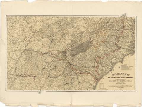
Military map showing the marches of the United States...


 Maps, plans and nautical charts
Military map showing the marches of the United States Forces under commamd of Maj. Genl. W.T. Sherman U.S.A. During... (1865)
Maps, plans and nautical charts
Military map showing the marches of the United States Forces under commamd of Maj. Genl. W.T. Sherman U.S.A. During... (1865)
 Disponible Holdings
 Section: Maps, plans and nautical charts
Uniform title: ESTADOS UNIDOS. SE. Operaciones bélicas. 1:1630000 (1863-1865)
Title: Military map showing the marches of the United States Forces under commamd of Maj. Genl. W.T. Sherman U.S.A. During the years 1863, 1864, 1865 / Compiled by order of Maj. Genl W.T. Sherman U.S.A. at Head Quarters Military Division of the Mississippi under the direction of But. Maj. W.L.B. Jenney Capt. A.D.C. U.S.A. ; Drawn by Capt. William Kossak Add1 A.D.C. U.S.A. and Jonh B. Muller draughtsman St. Louis. Mo. 1865 ; Engraved at Head Qrs. Corps of Engineers, U.S.A. by H.C. Evans & F. Courtenay
Material or type of resouce Area: Escala [ca. 1:1630000 ; proy. mericónica equivalente de Bonne] (O 92°45'--O 76°00'/N 38°30'--N 31°00')
Publication: St. Louis? : [Editor no identificado], 1865
Physical description: 1 mapa : col. ; 55 x 94 cm
Content type: Imagen cartográfica
Media type: computadora
Carrier type: recurso en línea
Notes: Comprende los estados de: Missouri, Illinois, Indiana, Kentucky, Virginia, Arkansas, Louisiana, Tennesse, Mississippi, Carolina del Norte, Carolina del Sur, Georgia y Alabama
Relación de los mapas, con el nombre de sus respectivos autores, que han servido de base para la formación de éste
Escala gráfica de 80 millas [= 7,9 cm] y nominal de 25 millas = 1 pulgada. Red geográfica de 1° en 1°
Orografía de perfil
Mediante líneas de colores se indican los movimientos de diversos cuerpos y divisiones de las tropas estadounidenses, así como la situación de las fortificaciones pertenecientes a ambos ejércitos
Materia / lugar / evento: Operaciones bélicas
Mapas generales
Estrategia
Fortificaciones
1865
Other authors: Sherman, W. T
Jenney, W.L.B
Evans, H.C
Courtenay, F
Kossak, William
Muller, John B
UDC: 912:355.4:355.43:623.1(73-12)"1863/1865"
73-12
Type of publication:
Maps
Rights:
Préstamo:
Disponible
