Map of the United States and Territories : Shewing the...


 Maps, plans and nautical charts
Map of the United States and Territories : Shewing the extent of Public Surveys and other details (Oct. 2nd. 1866)
Maps, plans and nautical charts
Map of the United States and Territories : Shewing the extent of Public Surveys and other details (Oct. 2nd. 1866)
 Disponible Holdings
 Section: Maps, plans and nautical charts
Uniform title: Estados Unidos. Divisiones administrativas. 1:3800000 (1866)
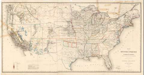
Title: Map of the United States and Territories : Shewing the extent of Public Surveys and other details / Constructed from the Plats and official sources of the General Land Office Under the direction of the Hon. Jos. S. Wilson commissioner by Theodore Franks Draughtsman 1866 ; Engraved by D. Mc. Clelland Washn. D. C
Material or type of resouce Area: Escala [ca. 1:3800000] (O 126° -- O 67° / N 49° -- N 25°)
Publication: [Washington] : Department of the Interior, General Land Office, Oct. 2nd. 1866
Physical description: 1 mapa : col. ; 72 x 141
Content type: Imagen cartográfica
Media type: computadora
Carrier type: recurso en línea
Notes: Figura la firma impresa, a modo de V° B°, de Jos. S. Wilson
Escala gráfica de 240 millas [= 10'2 cm]. Coordenadas también referidas al meridiano de Washington (O 49°--E 10°/N 49°--N 25°)
Orografía por normales
Presenta una serie de retículas trazadas sobre el territorio de algunos estados, que parecen indicar las mediciones realizadas con el fin de establecer los límites municipales. Nota explicativa de los símbolos utilizados en la red
Tabla de los signos convencionales y colores empleados para indicar la situación de : "Surveyor General Office" y "Land Office", así como para definir el terreno según su riqueza mineral
Límites entre estados marcados por líneas de color
Dos ejemplares duplicados, uno procedente de la colección de Manuel Rico y Sinobas y el otro de la colección Coello
Materia / lugar / evento: Divisiones administrativas
Mapas mineros
Municipios
Other authors: Wilson, Joseph S
Franks, Theodore
McClelland, D
Estados Unidos. General Land Office
Estados Unidos. Department of the Interior
UDC: 912:553]:352(73-2)"1866"
73
Type of publication:
Maps
Rights:
Préstamo:
Disponible
