A Plan of Table bay : with the road of the Cape of Good Hope


 Maps, plans and nautical charts
A Plan of Table bay : with the road of the Cape of Good Hope (1778)
Maps, plans and nautical charts
A Plan of Table bay : with the road of the Cape of Good Hope (1778)
 Disponible Holdings
 Section: Maps, plans and nautical charts
Uniform title: TABLA (Sudáfrica) (Bahía). Cartas náuticas. 1778. 1:42400 (177)
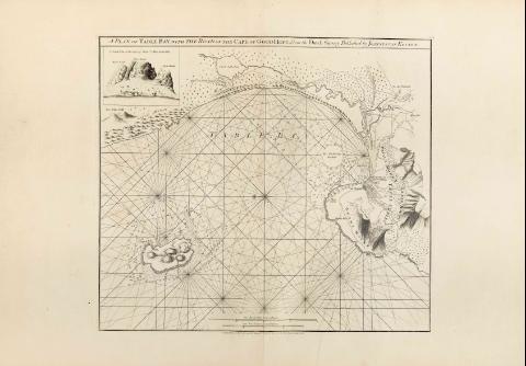
Title: A Plan of Table bay : with the road of the Cape of Good Hope [Mapa] / from the Dutch Survey; Published by Joannes Van Keulen; Robert Sayer and Jhon Bennett
Material or type of resouce Area: Escala [ca. 1:42400]
Publication: London : Robert Sayer and John Bennett, 1778
Physical description: 1 map. ; 48 x 54 cm
Notes: En : "The East India Pilot or oriental Navigator", part, I, map. n°23
Constan dos escalas gráficas, la primera de una milla holandesa de 15 al grado, de 17,5 cm de longitud, y la segunda de una legua marina de veinte al grado de 13,1 cm
Orientado con rosa y lis
Indica sondas batimétricas
Presenta nudos de rumbos
INserta una perspectiva de la costa titulada : " A South View of the Cape by Monsr l'Abbé de la Caille"
Materia / lugar / evento: Cartas náuticas
Bahías
Perspectivas de costas
Other authors: Keulen, Johannes van, 1654-1715
Bennett, John
Sayer, Robert, 1725-1794
L'Abbé de la Caille
UDC: 912:551.468]:742:551.468(680:26.04)"1778"
680:26.04 Table
Type of publication:
Maps
Rights:
Préstamo:
Disponible
