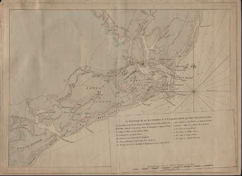
Sketch of the Environs of Charlestow in South Carolina


 Disponible Holdings
 Section: Maps, plans and nautical charts
Title: Sketch of the Environs of Charlestow in South Carolina / By Captain Geo. Sproule Assistant Engineer on the Spat
Material or type of resouce Area: Escala [ca. 1:130.000], 15 miles [= 18,4 cm]
Publication: [London : s.n.], 1st. June 1780
Physical description: 1 mapa : col. ; 40 x 56 cm
Content type: Imagen cartográfica
Media type: computadora
Carrier type: recurso en línea
Notes: Orientado con lis en nudo de rumbos
Indica veriles y sondas batimétricas
Relación de los principales buques y fortalezas militares indicados por clave alfabética
Figura representación de diversos barcos en el puerto
Señala la localización de los principales asentamientos militares por clave cromática
Indica cultivos, vegetación, núcleos de población, etc.
Notas explicativas escritas a lápiz indicando el ataque a la ciudad
Materia / lugar / evento: Operaciones bélicas
Núcleos de población
Charleston
Carolina del Sur
Other authors: Sproule, George, 1741-1817
UDC: 757
Type of publication:
 Maps
Maps
Rights:
Préstamo:
Disponible
