Plan of the Attack of Fort Sulivan near Charles Town in...


 Maps, plans and nautical charts
Plan of the Attack of Fort Sulivan near Charles Town in South Carolina : by a Squadron of His Majesty's Ships,on the... (1776)
Maps, plans and nautical charts
Plan of the Attack of Fort Sulivan near Charles Town in South Carolina : by a Squadron of His Majesty's Ships,on the... (1776)
 Disponible Holdings
 Section: Maps, plans and nautical charts
Uniform title: SULLIVAN (Estados Unidos) (Isla). Ataques (1776). 1:26000
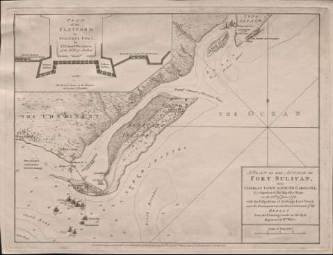
Title: Plan of the Attack of Fort Sulivan near Charles Town in South Carolina : by a Squadron of His Majesty's Ships,on the 28th. of June 1776. with the Disposition of the King's Land Forces, and the Encampments and Entrenchments of the Rebelds from the Drawing's made on the Spot / Engraved by Wm. Faden
Material or type of resouce Area: Escala [ca. 1:26.000], one mile [= 6,3 cm]
Publication: London : Publish'd according to Act of Parliament by Wm. Faden Corner of St. Martins Lane Charing Cross, 1776
Physical description: 1 mapa ; 29 x 38 cm
Content type: Imagen cartográfica
Media type: computadora
Carrier type: recurso en línea
Notes: Orientado con lis en nudo de rumbos
Indica sondas batimétricas
Relación de los principales campamentos y posiciones de los ejércitos indicados por clave cromática
Figura representación de embarcaciones con su nombre
Señala carreteras, masas forestales, canales, etc.
Inserta: "Plan of the Platform in Sulivans Fort". Lt. Colon el Thos. James of the Rl. Rt. of Artillery. Escala [ca. 1:8000], 550 feet [= 9,5 cm]
Materia / lugar / evento: Ataque
Operaciones navales
Sulivan
Carolina del Sur
Other authors: Faden, William, 1749-1836
UDC: 757 Sullivan
Type of publication:
Maps
Rights:
Préstamo:
Disponible
