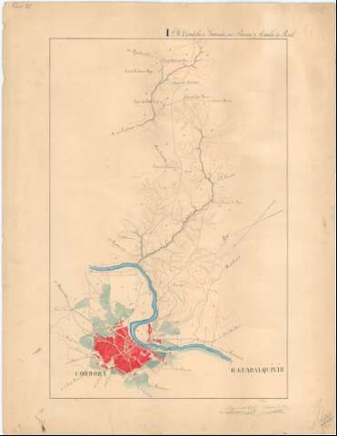
[Itinerario topográfico] de Córdoba a Granada por Baena y...


 Maps, plans and nautical charts
[Itinerario topográfico] de Córdoba a Granada por Baena y Alcalá La Real (1853)
Maps, plans and nautical charts
[Itinerario topográfico] de Córdoba a Granada por Baena y Alcalá La Real (1853)
 Disponible Holdings
 Section: Maps, plans and nautical charts
Uniform title: Córdoba. Itinerarios topográficos. Español. 1:20.000 (1853)
Title: [Itinerario topográfico] de Córdoba a Granada por Baena y Alcalá La Real / Miguel del Trell ; Rafael de Lorca
Material or type of resouce Area: Escala [1:20.000]
Publication: [1853]
Physical description: 1 mapa en 10 h. : ms., col. ; en h. de 75,5 x 58,3 cm
Content type: Imagen cartográfica
Media type: computadora
Carrier type: recurso en línea
Notes: Comprende parte de los partidos judiciales de Córdoba, Jaén y Granada
Título completado a partir del contenido del documento, habiéndosele añadido: "Itinerario topográfico"
Fecha tomada de la memoria de sign. C-41 N°13, con la cual se corresponde
Manuscritos firmados y rubricados por sus autores
Orientados al norte geográfico y magnético
Relieve representado por curvas de nivel
Indica la longitud total del itinerario: 166 km
Señala el número de vecinos de los núcleos de población más significativos
Existe una copia en tela para planos
Materia / lugar / evento: Itinerarios topográficos
Planos de población
Caminos
Granada
Granada (Provincia)
Córdoba (Provincia)
Andalucía
Other authors: Trell y Chacón, Miguel del, 1823-1883
Lorca, Rafael de
España. Ejército de Tierra. Cuerpo de Estado Mayor
UDC: (460.351 Córdoba)
Type of publication:
Maps
Rights:
Préstamo:
Disponible
