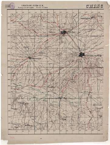
Chinc[hón] : 606


Section: Maps, plans and nautical charts
Uniform title: Chinchón (Madrid). Mapas topográficos. 1936-39. 1:25.000
Title: Chinc[hón] : 606 / Ejército del Centro, E.M
Material or type of resouce Area: Escala 1:25000
Publication: [1936-1939]
Physical description: 1 map. en 2 h. : ms., col., papel cebolla ; 91 x 68 cm
Content type: Imagen cartográfica
Media type: computadora
Carrier type: recurso en línea
Notes: Comprende la zona entre las poblaciones de Valdelaguna y Villaconejos
Cuadrícula de 1 km
Manuscrito en varias tintas
Relieve representado por curvas de nivel equidistantes 20 metros y puntos acotados
Indica la situación de fortificaciones enemigas
Se dispone únicamente de la mitad izquierda
Sello del Ejército del Centro, E.M. Servicio Geográfico de Campaña
Al tratarse de cartografía de campaña, para facilitar su lectura, se ha prescindido de la información relativa a los usos del suelo
Materia / lugar / evento: Colmenar de Oreja - Mapas
Madrid (Comunidad Autónoma) - Mapas
Chinchón - Mapas
Genre / form: Mapas topográficos
Other authors: España. Ejército del Centro. Estado Mayor
UDC: 912.43(460.27)"19"
460.27Chinchón
Type of publication:
 Maps
Maps
Rights:
Préstamo:
 Disponible
