Central Colorado : expeditions of 1873-1874 & 1875


 Maps, plans and nautical charts
Central Colorado : expeditions of 1873-1874 & 1875 (issued mar. 3d. 1876)
Maps, plans and nautical charts
Central Colorado : expeditions of 1873-1874 & 1875 (issued mar. 3d. 1876)
 Disponible Holdings
 Section: Maps, plans and nautical charts
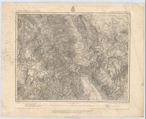
Title: Central Colorado : expeditions of 1873-1874 & 1875 / under the Command. of Ist. lieut. Geo. M. Wheeler, Corps of Engineers U.S. Army, parties of 1873-1874 & 1875 Ist. lieut. W.L. Marshall, Corps of Engineers, U.S. Army Executive Officer and Field Astronomer, Topographical Assistant Louis Nell, J.C. Spiller, J.J. Young by order of the Honorable the secretary of war under the direction of Brig. Gen. A.A. Humphreys, chief of engineers, U.S. Army ; Nell, Weyss, Herman & Lang Del.
Material or type of resouce Area: Escala [1:257496], 1 inch by 4 miles (O 106°52'30''--O 105°30'00''/N 39°00'00''--N 38°10'00'')
Publication: New York : The Graphic Co. Photo Lith, 39 & 41 Park Place, issued mar. 3d. 1876
Physical description: 1 mapa ; 38 x 49 cm
Content type: Imagen cartográfica
Media type: computadora
Carrier type: recurso en línea
Series: (Geographical explorations & surveys west of the 100 th. meridian)
Notes: Comprende la parte central del estado norteamericano de Colorado
Escala también dada en forma gráfica de 25 millas
Relieve por normales
Materia / lugar / evento: Mapas generales
1876
Other authors: Wheeler, George Montague
Marshall, W. L (William Louis), 1846-1920
Nell, Louis
Spiller, J.C
Young, J. J
Humphreys, A. A (Andrew Atkinson), 1810-1883
Weyss
Herman
Lang
Graphic Company Photo (Nueva York)
UDC: 788-191.2
Type of publication:
Maps
Rights:
Préstamo:
Disponible
