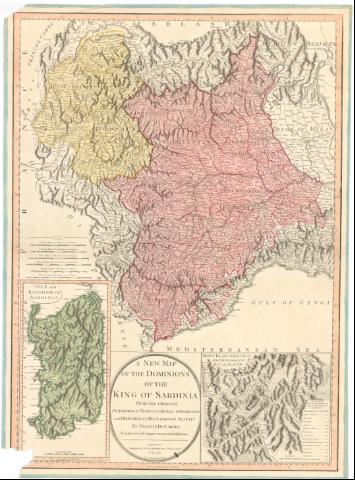
A new map of the dominions of the King of Sardinia from...


 Maps, plans and nautical charts
A new map of the dominions of the King of Sardinia from the original : Published at Turin with Royal approbation... (12th. may 1794)
Maps, plans and nautical charts
A new map of the dominions of the King of Sardinia from the original : Published at Turin with Royal approbation... (12th. may 1794)
 Disponible Holdings
 Section: Maps, plans and nautical charts
Uniform title: Italia. N.O. Mapas generales. 1:660000 (1794)
Title: A new map of the dominions of the King of Sardinia from the original : Published at Turin with Royal approbation and dedicated to his Sardinian Majesty / by Francis de Caroly, translated with Improvements and Additions ; Engraved by B. Baker, Islington
Material or type of resouce Area: Escala [ca. 1:660000], 30 common miles of Italy 60 to a Degree [= 8,4 cm]
Publication: London : Published by Laurie & Whittle, 53, Fleet Street, 12th. may 1794
Physical description: 1 mapa : col. ; 72,8x53,3 cm
Notes: Comprende el Piamonte, Saboya, Cerdeña y parte del valle de Aosta, Milan y Genova
Escalas gráficas de 25 millas comunes del Piamonte, 25 millas grandes del Piamonte, 40 millas de Milan, 35 millas inglesas y 15 leguas francesas comunes. Coordenadas referidas al meridiano de Londres (E5°30'-E9°38'/N46°36'-N42°32')
Relieve de perfil
Coloreado a mano en carmín, verde y amarillo los dominios del Rey de Cerdeña
Inserta : Montblanc in Fancigni and the subjacent Alps and Glaces. - Escala [ca. 1:320000], 6 British Miles [= 3,5 cm]
ITL
Materia / lugar / evento: Mapas generales
Montañas
1794
Saboya
Cerdeña
Piamonte
Milán
Valle de Aosta
Génova
Mont Blanc
Other authors: Caroly, Francesco de
Baker, Benjamin, fl. 1780-1824
Robert Laurie and James Whittle
UDC: 912(45-16)'1794'
912:551.43(234 Mont-blanc)
(234 Mont-blanc)
(44-328 Saboya)
(45 Cerdeña, isla)
(45-328 Aosta)
(45-15 Milan)
(45-15 Genova)
(45-328 Piamonte)
Type of publication:
Maps
Rights:
Préstamo:
Disponible
