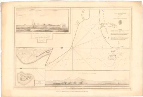
Plan of Angassea River. Lat. 19°.24'.N.


 Disponible Holdings
 Section: Maps, plans and nautical charts
Uniform title: India. Cartas náuticas. 1:46000 (1784)
Title: Plan of Angassea River. Lat. 19°.24'.N. / by Lientt. John Ringrofe From the Collection of Governer Horuby ; W.H.
Material or type of resouce Area: Escala [ca. 1:46000], 9 nautic miles [= 36,2 cm]
Publication, Production, Distribution, etc.: Publicación: [London ?] : Publish'd according to Act of Parliament by A. Dalrymple Octn. 17th..., 1784
Fabricación: [London ?] : Sold by R.B. Bate 21. Poultry for the Lords Commifsrs. of the Admiralty by their Appointment, 1784
Physical description: 1 carta náutica ; 34,4x50,3 cm
Content type: Imagen cartográfica
Media type: computadora
Carrier type: recurso en línea
Notes: Presenta además 2 vistas y un mapa de detalle de la zona
Orientado con lis en nudo de rumbos
Relieve representado por normales
Indica veriles, bajos, fondeaderos y sondas batimétricas en pies
Nota relativa a las profundidades del río
Sello de la Hydrographical Office
Materia / lugar / evento: Cartas náuticas
Ríos
1784
Angassea (Río)
Other authors: Riugrofe, John
Bate, R. B
Dalrymple, Alexander
UDC: 912:[551.46:556.53](540-15)'1784'
540-15
Type of publication:
 Maps
Maps
Rights:
Préstamo:
Disponible
