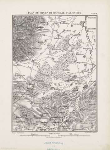
Plan du Champ de Bataille D'Arioviste


 Maps, plans and nautical charts
Plan du Champ de Bataille D'Arioviste (188-)
- Erhard Schièble, Georges, 1821-1880
Maps, plans and nautical charts
Plan du Champ de Bataille D'Arioviste (188-)
- Erhard Schièble, Georges, 1821-1880
 Disponible Holdings
 Section: Maps, plans and nautical charts
Title: Plan du Champ de Bataille D'Arioviste / gravé par Erhard Schièble
Author: Erhard Schièble, Georges, 1821-1880
Material or type of resouce Area: 1:100000
Publication: [París] : Henri Plon Editeur, rue Garanciére 10, [188-]
Physical description: 1 mapa ; 27 x 20 cm en h. de 37 x 27 cm
Content type: Imagen cartográfica
Media type: computadora
Carrier type: recurso en línea
Notes: Escala gráfica además en Kilómetros y millas romanas
Relieve representado por líneas perpendiculares normales
Copia digital. España : Ministerio de Cultura y Deporte. Subdirección General de Coordinación Bibliotecaria, 2010
Other titles: En: [Histoire de Jules César] [atlas]. - [Paris : Henri Plon, Editeur, rue Garanciére 8, 10, 188-]. - Planche 6
Materia / lugar / evento: Batallas
Guerra
Estrategia
Itinerarios
Imperio romano
Alto Rin ( Alsacia, Francia)
Nombre jerárquico lugar: Francia - Alto Rin
Related titles: ALTO RIN (Francia). 1:100000
UDC: 912:355.422]:[355.4:355.43:656.02:625.7](44 Alto Rin)'-0070/-0044'
37)
44 Alto Rin
Type of publication:
Maps
Rights:
