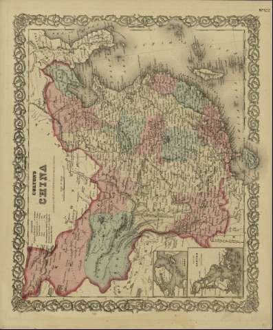
Colton's China


 Disponible Holdings
 Section: Maps, plans and nautical charts
Title: Colton's China / [drawn by George Woolworth Colton]
Author: Colton, G. Woolworth, 1827-1901
Material or type of resouce Area: Escala [ca. 1:12.345.666], 300 miles [= 4'5 cm] (E 90º--E 130º /N 45º--N 20º)
Publication: New York : published by S.W. and C.B. Colton & Co., [1872]
Physical description: 1 mapa : col. ; 36 x 44 cm
Content type: Imagen cartográfica
Media type: computadora
Carrier type: recurso en línea
Notes: Indica meridianos de origen: Washington y Greenwich ; Márgenes graduados.
Indica divisiones administrativas marcadas por colores.
Inserta nota: "Entered according to Act of Congress in the year 1855 by J.H. Colton & Co. in the Clerk's office of the district court for the southern district of New York".
Inserta: Harbor & Island of Amoy ; Map of Canton and adjacent islands.
Copia digital. España : Ministerio de Cultura y Deporte. Subdirección General de Coordinación Bibliotecaria, 2010
Materia / lugar / evento: Mapas políticos
Divisiones administrativas - Mapas
China - Mapas
Other authors: G.W. & C.B. Colton & Co
Related titles: China. 1:12345666
UDC: 912:911.2(510-2/-5)'1872'
510
Type of publication:
 Maps
Maps
Rights:
