The Jungleterry district with the adjacent provinces of...


 Maps, plans and nautical charts
The Jungleterry district with the adjacent provinces of Birboom, Rajemal, Boglipour & c: : comprending the countries...
- Rennell, James, 1742-1830
Maps, plans and nautical charts
The Jungleterry district with the adjacent provinces of Birboom, Rajemal, Boglipour & c: : comprending the countries...
- Rennell, James, 1742-1830
Section: Maps, plans and nautical charts
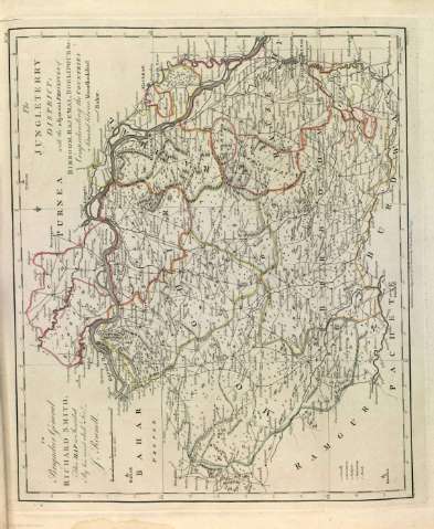
Title: The Jungleterry district with the adjacent provinces of Birboom, Rajemal, Boglipour & c: : comprending the countries situated between Moorshedabad and Bahad / By J. Rennell ; W. Harrison fc
Author: Rennell, James, 1742-1830
Material or type of resouce Area: Escala [ca. 1:74.853]. 20 Millas Inglesas [= 4'3 cm]
Physical description: 1 mapa : col. ; 49 x 40 cm
Content type: Imagen cartográfica
Media type: computadora
Carrier type: recurso en línea
Notes: En el ángulo superior izquierdo dedicatoria: "To Brigadier General Richard Smith, This Map is Inscribed By his most obedt. Sert. J. Rennell"
Orientado con lis
Márgenes graduados
Meridiano de origen: Calcutta
Relieve por montes de perfil y sombreado
Red hidrográfica y de caminos
Divisiones administrativas diferenciadas por color
Clave numérica
Copia digital. Madrid : Ministerio de Cultura, 2010
Other titles: En: A Bengal atlas : containing maps of the theatre of war and commerce on that side of Hindoostan. - Inglaterra : [Editor no identificado], 1780. - [Lám. 2]
Materia / lugar / evento: Mapas generales
Núcleos de población
Navegación marítima
Rutas comerciales
Mares
Montañas
Ríos
1780
India
Other authors: Harrison, William
Related titles: Jungleterry (India) (Bengala). Mapas generales. 1779
UDC: (540)"1779"
Type of publication:
Maps
