Grand bay of Pasamaquody-Coopscook-Campo Bello, Island...


 Maps, plans and nautical charts
Grand bay of Pasamaquody-Coopscook-Campo Bello, Island-The Wolf island (1780)
- Des Barres, Joseph F. W (Joseph Frederick Wallet), 1722-1824
Maps, plans and nautical charts
Grand bay of Pasamaquody-Coopscook-Campo Bello, Island-The Wolf island (1780)
- Des Barres, Joseph F. W (Joseph Frederick Wallet), 1722-1824
 Disponible Holdings
 Section: Maps, plans and nautical charts
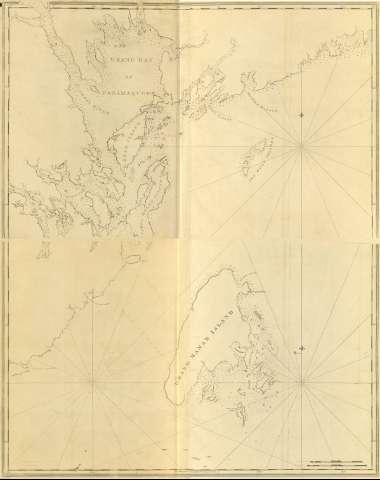
Title: Grand bay of Pasamaquody-Coopscook-Campo Bello, Island-The Wolf island / Joseph Frederick Wallet Des Barres ; [Tomkins Scripsir, H. Ashby Sculpsit]
Material or type of resouce Area: Escala [ca. 1:49500] (O 67°10'--O 66°26'/N 45°17'--N 44°57')
Publication: [London?] : J. F. W. Des Barres, 1780
Physical description: 1 mapa ; 76 x 120 cm
Content type: Imagen cartográfica
Media type: computadora
Carrier type: recurso en línea
Notes: Charts of the coast and harbors of New England, Nº 2
Título propio tomado del índice del documento, siendo común para la h. nº 3
Graduado, longitud tomada respecto del meridiano de Greenwich
Escala hallada a partir de un minuto de latitud
Orientadocon lis
Presenta análisis batimétrico y nudo de rumbos
Other titles: En: The Atlantic Neptune. - [London?] : J. F. W. Des Barres, 1774- 1780. - 2
Other authors: Ashby, Harry, 1744-1818
Tomkins, Thomas, 1743-1816
Related titles: Pasamaquody (Estados Unidos). Cartas naúticas. 1:49500 (1780)
UDC: 912:551.46]:551.468:551.42(741)"17"
741:26.04 Pasamaquody
Type of publication:
Maps
Préstamo:
 Disponible sólo para consulta en sala
