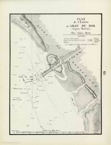
Plan de l'Entrée du Grau du Roi : (Aigues - Mortes)


 Disponible Holdings
 Section: Maps, plans and nautical charts
Uniform title: Le Grau-du-Roy. Cartas náuticas. 1859. Francés. 1:11.000
Title: Plan de l'Entrée du Grau du Roi : (Aigues - Mortes)
Material or type of resouce Area: Escala [ca. 1:11.000]. 1 Mille Marin [= 12,5 cm]
Publication: [Marseille] : [Maistre, hidrographe, editeur], [1859]
Physical description: 1 carta náutica ; 29x22 cm
Content type: Imagen cartográfica
Media type: computadora
Carrier type: recurso en línea
Notes: Orientada con flecha indicando la declinación magnética. Coordenadas y altitud referidas al Faro Aigues-Mortes. Longitud oriental de París
Relieve por sombreado
Indica bajos, veriles, fondeaderos y sondas batimétricas expresadas en metros
Copia digital. España : Ministerio de Cultura. Dirección General del Libro, Archivos y Bibliotecas, 2010
Materia / lugar / evento: Cartas náuticas
Batimetría
Navegación fluvial
Golfos
Le Grau-du-Roy
Gard
Francia
Other authors: Maistre, Jh
UDC: 912:551.46]:627.7(44 Le-Grau-du-Roy)
(44 Le-Grau-du-Roy)
Type of publication:
 Maps
Maps
Rights:
Préstamo:
Disponible
