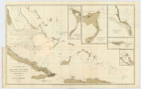
Chart of part of the Bahama Islands showing the tracks...
Section: Maps, plans and nautical charts
Uniform title: BAHAMAS. Cartas náuticas. 1881. 1:1133786 (1492-1502)
Title: Chart of part of the Bahama Islands showing the tracks ascribed to Columbus on his descovery of the New World / Compiled and drawn, under the direction of W.T. Bright, In charge of Drawing Division, by T.J. O'Sullivan draughtsman
Material or type of resouce Area: Escala [ca. 1:1134786] (O 77°50'-O 68°10'/N 24°55'-N 19°10')
Publication: [Washington] : U.S. Coast and Geodetic Survey Office, April 1881
Physical description: 1 carta náutica ; 56 x 91 cm
Content type: Imagen cartográfica
Media type: computadora
Carrier type: recurso en línea
Notes: Escala hallada a partir de 1° de latitud [= 9'8 cm]. Orientado con gráfico de declinación magnética
Relieve por normales y puntos acotados
Indica sondas batimétricas, así como la línea de derrota seguida por Cristóbal Colón
Inserta: "Crooked islands" ; "Acklins island" ; "Lang island" ; "Samana or At wood Cay" ; "Clarence Harbour"
Materia / lugar / evento: Cartas náuticas
Batimetría
Islas
Cayos
Derroteros
1881
Cuba
República Dominicana
Haití
Crooked
Acklins
Isla Larga
Clarence Town
Cayo Samaná (Isla)
Other authors: Bright, W. J
O'Sullivan, T. J
Estados Unidos. Coast and Geodetic Survey
UDC: (729.61)
Type of publication:
![]() Maps
Maps
Préstamo:
![]() Disponible
Disponible


