A New map of the Hindoostan from the latest authorities :...


 Maps, plans and nautical charts
A New map of the Hindoostan from the latest authorities : chiefly from the Actual Surveys made by Major James... (1789)
- Rennell, James, 1742-1830
Maps, plans and nautical charts
A New map of the Hindoostan from the latest authorities : chiefly from the Actual Surveys made by Major James... (1789)
- Rennell, James, 1742-1830
 Disponible Holdings
 Section: Maps, plans and nautical charts
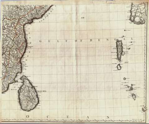
Title: A New map of the Hindoostan from the latest authorities : chiefly from the Actual Surveys made by Major James Rennell, Surveyor General to the Hble. East India Company, of the Bengal provinces, and of the countries lying between them and Dehly : the whole exhibiting all the military roads and passes as well as the most accurate Division of the British Possessions in the East Indies
Author: Rennell, James, 1742-1830
[A New map of the Hindoostan from the latest authorities] All editions
Characteristics of the edition: 1789. 1:2575000. Inglés
Material or type of resouce Area: Escala [ca. 1:2.575.000]
Publication: London : Publish'd by Robert Sayer Map & Printseller, n° 53, Fleet Street, as the Act directs, 1789
Physical description: 1 mapa en 4h. : col. ; 117 x 146 ccm, en h. de 62 x 75 cm o menor
Content type: Imagen cartográfica
Media type: computadora
Carrier type: recurso en línea
Notes: Comprende la península del Indostán, Birmania y el sur del Tibet
Escalas gráficas de 200 millas estatutarias [= 12'5 cm], 80 leguas de 30 en grado, 60 leguas náuticas de 20 en grado, 100 "Jeribi" y 120 "Rifmi". Coordenadas referidas a los meridianos de Ferro (E 75°20'--E 114°40'/N 30°30'--N 4°20') y París (E 57°50'--E 97°10'). Red geográfica de 1° en 1°
Orografía de perfil. Indica bajos y veriles
Relación de las distintas provincias en que están divididas las posesiones británicas en la península, indicadas por clave cromática
Título, autor, impresor y escalas enmarcados en dos cartelas
Reproducción digital
Genre / form: Documentos archivísticos
Mapas generales
Other authors: Sayer, Robert, 1725-1794
España. Dirección de Hidrografía, productor. Expediciones a Indias
Museo Naval (Madrid). Archivo. Documentos gráficos, Mapas
Type of publication:
Maps
Rights:
Préstamo:
Disponible
