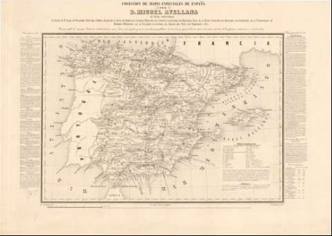
Mapa Industrial [de España]


 Disponible Holdings
 Section: Maps, plans and nautical charts
Title: Mapa Industrial [de España] / por Miguel Avellana ; M. Laborda grabó
Author: Avellana, Miguel
[Mapa Industrial] All editions
Characteristics of the edition: 185. 1:2.850.000. Español
Material or type of resouce Area: Escala [ca. 1:2.850.000]. 60 leguas legales [= 11,8 cm]
Publication: Madrid : Lit. Aragón, Urosas, 10, [185-]
Physical description: 1 mapa : grab., montado sobre tela ; 36 x 52 cm
Content type: Imagen cartográfica
Media type: computadora
Carrier type: recurso en línea
Series: (Colección de Mapas Especiales de España ; 11)
Notes: Dedicatoria: "Al Illmo. Sr. D. Angel de Villalobos, Diputado a Cortes, Asesor de la Junta de Fábricas de Cataluña, Director del Instituto Industrial de Barcelona..."
Coordenadas referidas al meridiano de Madrid (O 7°20'--E 9°45'/N 44°00'--N 35°00'). Red geográfica de 1° en 1°
Relieve representado por curvas de configuración
Tabla de abreviaturas para indicar los distintos tipos de industrias y de signos convencionales para las poblaciones con distinto grado de industrialización, escuelas industriales, casas moneda y fábricas de cigarros
En los márgenes consta una relación de provincias con el número, localización y clase de industrias que posee y una nota "Idea general de la Industria" que expone una clasificación de las industrias y su localización en poblaciones de distinta categoría, seguida de una relación de las industrias existentes en Cataluña
Genre / form: Mapas temáticos
Other authors: Laborda, M
Litografía de J. Aragón (Madrid)
UDC: 912:65(460)"1859"
(460)
Type of publication:
 Maps
Maps
Rights:
Préstamo:
Disponible
