Spain and Portugal : divided into their respective...


 Maps, plans and nautical charts
Spain and Portugal : divided into their respective Kingdoms and Provinces from the Spanish and Portuguese Provincial... (1796)
- Faden, William, 1749-1836
Maps, plans and nautical charts
Spain and Portugal : divided into their respective Kingdoms and Provinces from the Spanish and Portuguese Provincial... (1796)
- Faden, William, 1749-1836
 Disponible Holdings
 Section: Maps, plans and nautical charts
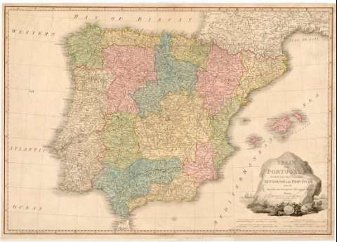
Title: Spain and Portugal : divided into their respective Kingdoms and Provinces from the Spanish and Portuguese Provincial Maps
Author: Faden, William, 1749-1836
[Spain and Portugal] All editions
Characteristics of the edition: 1796. 1:2.100.000. Inglés
Material or type of resouce Area: Escala [ca. 1:2.100.000]. 30 leguas españolas de 17 1/2 al grado [= 9 cm]
Publication: London : Published by W. Faden Geographer to His Majesty and to H.R.H. the Prince of Wales, 1796
Physical description: 1 mapa : col., montado sobre tela ; 49 x 71 cm
Content type: Imagen cartográfica
Media type: computadora
Carrier type: recurso en línea
Notes: Escala también expresada en otras unidades. Coordenadas referidas al meridiano de Londres (O 11°30'--E 5°50'/N 44°10'--N 35°10'). Red geográfica de 1° en 1°
Orografía representada por montes de perfil
Señala los límites entre las provincias y regiones de España y Portugal, diferenciadas con color
Título enmarcado en cartela, en una roca, con representaciones de frutos, animales, y un medallón con la leyenda "Hispania SC, sobre un paisaje marítimo con naves
Genre / form: Mapas generales
UDC: (460)
(469)
Type of publication:
Maps
Rights:
Préstamo:
Disponible
