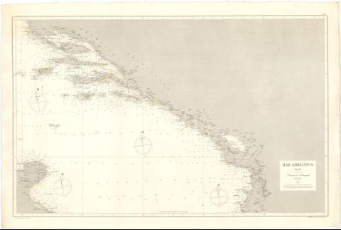
Mar Adriático : Hoja IV


Section: Maps, plans and nautical charts
Uniform title: ADRIATICO (Mar). Cartas náuticas. 1:450000 (1888)
Title: Mar Adriático : Hoja IV / J. Galvan la grabó, P. Bacot grabó la letra
Material or type of resouce Area: Escala [ca. 1:450000]
Publication: Madrid : Dirección de Hidrografía, 1888
Physical description: 1 carta náutica ; 61,2 x 97,7 cm en h. de 70,6 x 102,2 cm
Notes: Escala hallada a partir de diez minutos de la latitud [= 4,2 cm]. Coordenadas referidas al meridiano de San Fernando (E21°05'-E26°15'/N41°25'-N39°00'). Red geográfica de 1° en 1°. Orientado con estrella y flecha. Figura gráfico de declinación magnética
Relieve representado por normales
Indica veriles y sondas batimétricas expresadas en metros. Clave hidrográfica para determinar la calidad del fondo
Señala faros cuyos fanales están iluminados en amarillo y carmín
En el ángulo superior derecho: "864"
ITL
Materia / lugar / evento: Cartas náuticas
Costas
Mares
Faros
1888
Mediterráneo
Tarento
Italia
Other authors: Bacot, Pierre Adolphe
Galván y Candela, José María, 1837-1899
España. Dirección de Hidrografía
UDC: 912:551.46]:551.468(262.3-13 Adriático)'1888'
(26.04 Tarento)(45)
Type of publication:
 Maps
Maps
Rights:
Préstamo:
 Disponible
