Map of the territory of the United States, West of the...


 Maps, plans and nautical charts
Map of the territory of the United States, West of the Mississippi River (1879)
Maps, plans and nautical charts
Map of the territory of the United States, West of the Mississippi River (1879)
 Disponible Holdings
 Section: Maps, plans and nautical charts
Uniform title: Estados Unidos. Mapas generales (1879?). 1:2000000
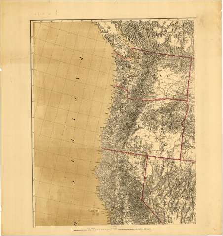
Title: Map of the territory of the United States, West of the Mississippi River / Prepared by authority of the Chief of Engineers, under the direction of Brig. Gen. A.A. Humphreys, Chief of Engrs. But. Major General U.S.A. ; by Edward Freyhold, 1879
Material or type of resouce Area: Escala 1:2000000 ; [proy. de Bonne] (O 133°--O 78°/N 51°--N 23°)
Publication: [Lugar de publicación no identificado] : [Editor no identificado]], 1879
Physical description: 1 mapa en 6 hoja : col. ; 157 x 210 cm, en hoja de 90 x 84 cm o menor
Content type: Imagen cartográfica
Media type: computadora
Carrier type: recurso en línea
Notes: Comprende desde el estado de Alabama y Lago Hurón, hasta la costa oriental, incluyendo parte del norte de México
Escala gráfica de 150 millas [= 12'1 cm]. Coordenadas también referidas al meridiano de Washington (O 55°--O 2°). Red geográfica de 1° en 1°
Orografía por normales
Nota explicativa de los motivos del levantamiento del mapa
Límites entre los estados resaltados por líneas de color carmín
Sobre el título figura un escudo, posiblemente de la Secretaria de Guerra
Inserta: "Territory of Alaska". Escala [ca. 1:9000000], 400 millas estatuarias [= 7'2 cm]
Materia / lugar / evento: Mapas generales
Other authors: Freyhold, Edward
Humphreys, A. A (Andrew Atkinson), 1810-1883
Estados Unidos. War Department
Estados Unidos. Army. Office of the Chief of Engineers
UDC: 912(73)"1879"
73
Type of publication:
Maps
Rights:
Préstamo:
Disponible
