Map of the battlefield of Chattanooga : Prepared to...


 Maps, plans and nautical charts
Map of the battlefield of Chattanooga : Prepared to accompany Report of Maj. Genl. U.S. Grant (1875)
Maps, plans and nautical charts
Map of the battlefield of Chattanooga : Prepared to accompany Report of Maj. Genl. U.S. Grant (1875)
 Disponible Holdings
 Section: Maps, plans and nautical charts
Uniform title: CHATTANOOGA (Estados Unidos) (Tennessee). Operaciones bélicas. 1875 (1864). 1:27000
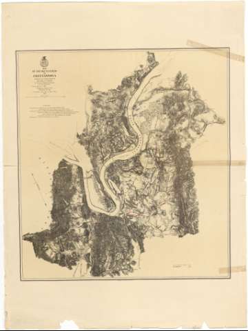
Title: Map of the battlefield of Chattanooga : Prepared to accompany Report of Maj. Genl. U.S. Grant / By direction of Brigd. Genl. W.F. Smith Chief Engr. Milty. Div. Miss. 1864 ; Published by Authority of the Secretary of War in the office of the Chief of Engrs., U.S.A. 1875
Material or type of resouce Area: Escala [ca. 1:27000]
Publication: [Washington] : Secretary of War, Office of the Chief of Engrs. USA, 1875
Physical description: 1 map : col. ; 72 x 67 cm
Content type: Imagen cartográfica
Media type: computadora
Carrier type: recurso en línea
Notes: Representa la ciudad y sus alrededores, indicando la posición de los contendientes en la Guerra de Secesión (línea roja para los confederados y azul para las tropas federales)
Presenta la relación de los mapas, con el nombre de sus respectivos autores, que han servido de base para la formación de éste
Junto a la fecha de 1864 aparece manuscrito, "25 de Noviembre"
Escala gráfica de 2 millas [= 11'8 cm]
Orientado con flecha
Orografía por normales
Materia / lugar / evento: Batalla de Chattanooga
Operaciones bélicas
Mapas topográficos
Estrategia militar
1863
Tennessee
Other authors: Smith, W. F
Estados Unidos. War Department
Estados Unidos. Army. Office of the Chief of Engineers
UDC: 912:355.4:355.43(768 Chattanooga)"1864"
768 Chattanooga
Type of publication:
Maps
Rights:
Préstamo:
Disponible
