La Martinique


Section: Maps, plans and nautical charts
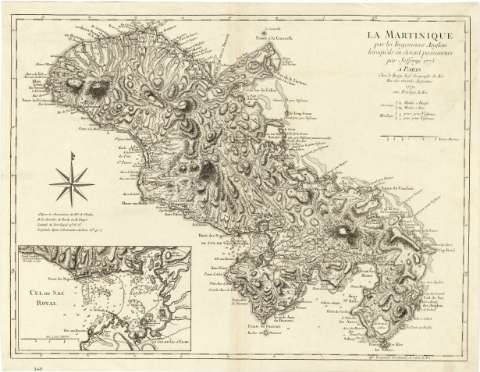
Title: La Martinique / par les Ingenieurs Anglais lorsqu'ils ar étoient possesseurs, par Jefferys 1775
Material or type of resouce Area: Escala [ca. 1:152000]
Publication: A Paris : Chez le Rouge Ingr. Geographe du Roi Rue des Grands Augustins, 1779 avec privilege du Roi
Physical description: 1 mapa : montado sobre tela ; 44 x 58 cm
Content type: Imagen cartográfica
Media type: computadora
Carrier type: recurso en línea
Notes: Escala gráfica de 2 leguas marinas [= 7,3 cm]. Coordenadas referidas al meridiano de Ferro (O 43°38'-O 42°50'/N 14°56'-N 14°22'). Orientado con media lis en rosa de 8 vientos
Relieve representado por normales
Indica fondeaderos y sondas batimétricas
Señala los molinos movidos por tracción animal
En el margen izquierdo nota sobre las coordenadas de Fort Royal según diversos geógrafos
Inserta: "Cul de Sac Royal". -Escala [ca. 1:74000], de una legua marina [= 7,5 cm]. Hoy en día se conoce esta bahía como Fort de France. Se señalan las sondas batimétricas, fondeaderos, cayos y calidad del fondo marino
Materia / lugar / evento: Mapas generales
Cartas náuticas
Topónimos antiguos
Islas
Industria molinera
Bahías
Fondeaderos
1779
Antillas
Martinica
UDC: 729.81 Martinica
Type of publication:
 Maps
Maps
Rights:
Préstamo:
 Disponible
