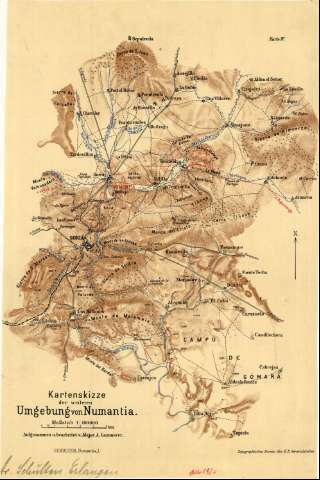
Kartenskizze des weiteren Umgebung von Numantia


 Disponible Holdings
 Section: Maps, plans and nautical charts
Uniform title: SORIA (Partido judicial). Mapas generales. 1:100000 (1920?)
Title: Kartenskizze des weiteren Umgebung von Numantia / Aufgenommen v. bearbeitet v. Major A. Lammerer
Material or type of resouce Area: Escala 1:100000
Publication: [Lugar de publicación no identificado] : Topographisches Bureau des K.B. Generalstabes, [1920?]
Physical description: 1 mapa : col., montado sobre tela ; 37 x 25 cm
Content type: Imagen cartográfica
Media type: computadora
Carrier type: recurso en línea
Notes: Comprende parte del partido judicial de Soria, entre las poblaciones de Ribarroya, Arancón, Sepúlveda de la Sierra y Soria
Firmado por el Prof. Dr. Schulten Erlangen
Fecha de publicación tomada del catálago del SGE: "Provincias de Soria, Segovia, Avila, Valladolid y Palencia. Siglos XVIII-XIX". 1967, p. 201
Escala también dada en forma gráfica de 5 kilómetros. Orientado al norte
Orografía por normales
Indica la situación de los campamentos romanos que se asentaron en este área en torno a Numancia
En el margen inferior: "Schulten, Numantia I" ; y en el superior: "Karte IV"
Materia / lugar / evento: Mapas generales
Restos arqueológicos
1920
Soria (Provincia)
Castilla y León
Other authors: Lammerer, A
Topographischen Bureau des K.B. Generalstates
UDC: 912:902.2(463.815)"1920"
463.815
Type of publication:
 Maps
Maps
Rights:
Préstamo:
Disponible
