Karte von Russisch - Chinesischen Grenzgebiet am...


 Maps, plans and nautical charts
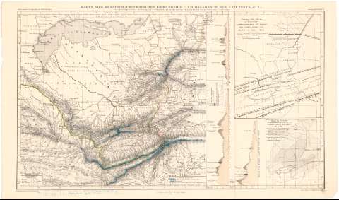
Karte von Russisch - Chinesischen Grenzgebiet am Balkhasch - See und Issyk - Kul (1858)
Maps, plans and nautical charts
Karte von Russisch - Chinesischen Grenzgebiet am Balkhasch - See und Issyk - Kul (1858)
 Disponible Holdings
 Section: Maps, plans and nautical charts
Uniform title: KAZAJSTAN. Mapas generales. 1:2870000 (1858)
Title: Karte von Russisch - Chinesischen Grenzgebiet am Balkhasch - See und Issyk - Kul / Nach handschriftlichen Zeichnungen P. v. Semenow's, und andern autbentischen russischen Dokumenten von A. Petermann ; B. Hassenstein del A. Petermann dir.
Material or type of resouce Area: Escala 1:2870000 ; [proyec. cónica] (E73°00'-E82°40'/N47°00'-N41°00')
Publication: Gotha : Justus Perthes, 1858 (in Gotha : Lith. Anstv. v. C. Hellfarth)
Physical description: 1 mapa : col. ; 24'6x42'4 cm en h. de 26'3x46'3 cm
Content type: Imagen cartográfica
Media type: computadora
Carrier type: recurso en línea
Notes: Comprende la región de Kazajstán al suroeste de la Unión Soviética
Presenta además tres perfiles y dos mapas de detalle de la zona
Pertenece al 'Petermann's Geographische Mittheilungen, Jabrgang 1858, Tafel 16
Escala grafica de 10 millas alemanas de 15 al grado [= 2'5 cm]. Coordenadas ademas referidas al meridiano de Paris (E71°50'-E79°50'/N47°00'-N41°00'). Red geográfica de 1° en 1°
Relieve representado por normales
Tabla de signos convencionales para indicar distintos accidentes geográficos y otra de abreviaturas
Procede de la 'Colección Coello'
Other authors: Petermann, Augustus Herman
Hassenstein, Bruno
Perthes, Justus, 1749-1816
Hellfarth, C
UDC: 912:528.9(47-328 Kazajistan)'1858'
47-328 Kazajstan
Type of publication:
Maps
Rights:
Préstamo:
Disponible
