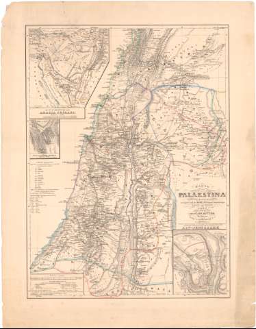
Karte von Palaestina nach den neuesten quellen,...


 Maps, plans and nautical charts
Karte von Palaestina nach den neuesten quellen, vorzuglich nach den Robinson schen Untersuchungen (1843)
Maps, plans and nautical charts
Karte von Palaestina nach den neuesten quellen, vorzuglich nach den Robinson schen Untersuchungen (1843)
 Disponible Holdings
 Section: Maps, plans and nautical charts
Title: Karte von Palaestina nach den neuesten quellen, vorzuglich nach den Robinson schen Untersuchungen / bearbeitet und gezeichnet von H. Kie pert ; geo - lithogr. Anst. v. H. Mahhnann
Edición: Ed. 1842, ber.
Material or type of resouce Area: Escala 1:600000 ; [proyec. cónica]
Publication: Berlin : Simon Schropp und C., 1843
Physical description: 1 mapa : col. ; 57,5x42,9 cm en h. de 69,1x53,6 cm
Content type: Imagen cartográfica
Media type: computadora
Carrier type: recurso en línea
Notes: Edición además 'Berlin : prof. Dn. Carl Ritter, 1842'
Escalas graficas de 8 millas geográficas [= 9,6 cm] y de 40 millas romanas [= 9,6 cm]. Coordenadas referidas al meridiano de Paris (E31°55'-E34°40'/N34°04'-N31°00'). Red geográfica de 30' en 30'
Relieve representado por normales
Relación de las principales divisiones administrativas tal y como existian antes y durante el establecimiento de las 12 tribus de Israel
Tabla de signos convencionales para indicar núcleos de población de distinta categoria, etc.
Inserta : Alt - Jerusalem. - Escala [ca. 1:21000]. Die Sinai - Halbínsel oder Arabia Petraea. - Escala 1:2400000. Das Sinai - oder Horeb - Gebinge. - Escala 1:200000
Materia / lugar / evento: Geografía bíblica
Divisiones administrativas
1843
Israel
Jordania
Líbano
UDC: 912:913.2/.9(394 Palestina)'-12'
(569.4)
(569.5)
(569.3)
Type of publication:
Maps
Rights:
Préstamo:
Disponible
