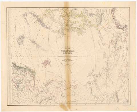
Karte der Nord Polar Lander = map of the countries...


 Maps, plans and nautical charts
Karte der Nord Polar Lander = map of the countries around the Artic Pole (1855)
Maps, plans and nautical charts
Karte der Nord Polar Lander = map of the countries around the Artic Pole (1855)
 Disponible Holdings
 Section: Maps, plans and nautical charts
Uniform title: POLO NORTE. Temperatura atmosférica. 1:11000000 (1855)
Title: Karte der Nord Polar Lander = map of the countries around the Artic Pole / Entworfen und Bearbeitet von Dr. Heinrich Kiepert ; Nebst Darstellung der War meverbreitung fur Januar, Juli und das Jahr von H.W. Dove ; H. Mahlmann, Geo - Lithograph.
Material or type of resouce Area: Escala [ca. 1:11000000 ; proyec. equivalente] (O180°-E180°/N90°-N63°)
Publication: Berlin : Bei Dietrich Reimer, 1855 (Berlin : Druck von A. Dettmers)
Physical description: 1 mapa : col., montado sobre tela ; 55,4x68,5 cm
Content type: Imagen cartográfica
Media type: computadora
Carrier type: recurso en línea
Notes: Escala hallada a partir de un grado de latitud [= 1 cm]. Red geográfica de 5° en 5°
Relieve representado por normales
Tabla de signos convencionales para indicar las líneas isotermas
Materia / lugar / evento: Temperatura atmosférica
1855
Other authors: Kiepert, Heinrich
Dettmers, A
Dove, Heinrich Wilhelm
Mahlmann, Heinrich
Reimer, Dietrich
UDC: 912:551.524(98)'1855'
98
Type of publication:
Maps
Rights:
Préstamo:
Disponible
