Itinerario topográfico de Madrid a Cordova por Toledo y...


 Maps, plans and nautical charts
Itinerario topográfico de Madrid a Cordova por Toledo y Ciudad Real
Maps, plans and nautical charts
Itinerario topográfico de Madrid a Cordova por Toledo y Ciudad Real
 Disponible Holdings
 Section: Maps, plans and nautical charts
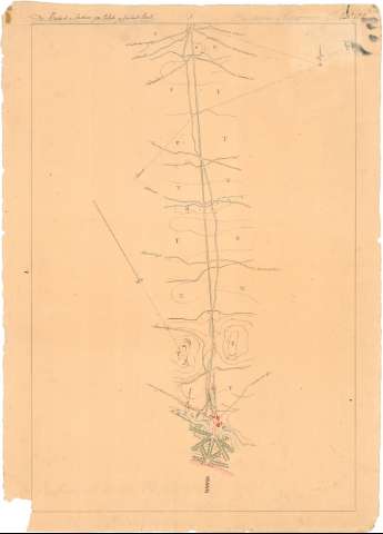
Title: Itinerario topográfico de Madrid a Cordova por Toledo y Ciudad Real / Levantado con la brújula por el Comandante D. Juan de Dios Sevilla, y los Capitanes D. Teodoro Pizarro, D. José Gomez de Arteche, D. Federico Fernandez del cuerpo de E.M. año de 1848
Material or type of resouce Area: Escala 1:20000
Physical description: 1 map. en 27 h. : ms., col. ; 79 x 55,9 cm o menor
Notes: Documento imcompleto pues falta la parte desde la villa de Adamuz hasta la ciudad de Córdoba, comprendiendo, por tanto, la zona meridional de la provincia de Madrid, central de las de Toledo y Ciudad Real y septentrional de la de Córdoba, y pasando, entre otras por, las poblaciones de Illescas, Toledo, Yébenes, Fernán Caballero, Ciudad Real y Calatrava
Título completando a partir del contenido del documénto, habiéndose añadido: "Itinerario topográfico"
Itinerario dividido en tres tramos, cada uno de los cuales cuenta con portada y menciones de responsabilidad propias: el primero, "De Madrid a toledo" y el tercero "De Ciudad Real a Córdoba por Almodóvar del Campo", fueros levantados por Juan de Dios Sevilla, Teodoro Pizarro y José Gómez de Arteche ; y el segundo "De Toledo a Ciudad Real" por Federico Fernández y José Gómez de Arteche
Escala también dada de forma gráfica, en 10000 pies castellanos
Orientadas al norte geográfico y magnético
Orografía por normales y curvas de configuración croquisadas sin cotas
Tablas de signos convencionales para indicar, por un lado, los diferentes tipos de caminos, molinos, puentes, núcleos de población de distinta categoría, y accidentes geográficos de mayor interés y por otro, la vegetación y especies de cultivo más significativos, respectivamente
Inserta: "Toledo desde la Fábrica de Armas", perspectiva de la ciudad con una relación de sus edificios más significativos indicados por clave numérica
Se corresponde, al parecer, con la memoria de sign. C.47-No. 2
Materia / lugar / evento: Itinerarios topográficos
1843
1848
Córdoba (Provincia)
Ciudad Real (Provincia)
Madrid
Other authors: Fernández San Román, Federico
Gómez de Arteche, José, 1821-1906
Pizarro, Teodoro
Sevilla, Juan de Dios
España. Ejército de Tierra. Cuerpo de Estado Mayor
UDC: 912:528.42(464.1-13)(464.2-191.2)(464.3-191.2)(468.13-17)"1848"
464.1-13
464.2-191.2
464.3-191.2
464.13-17
Type of publication:
Maps
Rights:
Préstamo:
Disponible
