Islas Vírgenes


Section: Maps, plans and nautical charts
Uniform title: VIRGENES (Islas). Cartas náuticas. 1:291000 (1855)
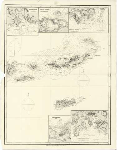
Title: Islas Vírgenes [Mapa]
Material or type of resouce Area: Escala [ca. 1:291000]
Publication: London : Published by James Imray and Son, 89 Minories & Tower Hill, [1855]
Physical description: 1 map. ; 82'0 x 62'5 cm, pleg. en 45'8 x 71'0 cm
Notes: Título redactado a partir del contenido del documento
Fecha de edición tomada del "Tooley's Dictionary of Mapmakers", 1979
Escala hallada a partir de un grado de latitud [= 38'2 cm]. Coordenadas referidas a un meridiano que no se especifica (O 65°45'--O 64°00'/N 17°07'--N 19°15'). Red geográfica de 30' en 30' Orientado con tres gráficos de decinación magnética
Orografía por normales y puntos acotados. Sondas batimétricas
Indica los fondeaderos, calidad del fondo marino, veriles y bajos
Situación de los faros resaltados con colores amarillo y rojo
Inserta: "Road Harbour".- Escala [ca. 1:34000]; "Gorda Sound".- Escala [ca. 1:39000], "S.E. end of Culebra".- Escala [ca. 1:42000]; "Christianstaed".- Escala [ca. 1:3500]; "St. Thomas Harbour".- Escala [ca. 1:29000]
Materia / lugar / evento: Cartas náuticas
Faros
Fondeaderos
1855
Sotavento (Islas)
Other authors: James Imray and Son
UDC: 912:551.46]:627.231:627.715(729.71/72)"1855"
729.71/72
Type of publication:
 Maps
Maps
Rights:
Préstamo:
 Disponible
