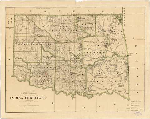
Indian Territory


Section: Maps, plans and nautical charts
Uniform title: OKLAHOMA (Estados Unidos). Mapas generales. 1:760320 (1883)
Title: Indian Territory / Department of the Interior, General Land Office, S.S. Burdett, Commissioner ; compiled from the official Records of the General Land Office and other sources by C. Roeser, Principal Draughtsman G.L.O.
Material or type of resouce Area: Escala [1:760320 ; proy. cónica equidistante] (O 100°00'--O 94°26'/ N 37°00'--N 33°35')
Publication: N.Y. [i.e. New York] : Photo lith & print. by Julius Bien 16 & 18 Park Place..., 1876
Physical description: 1 mapa : col. ; 63 x 82 cm
Content type: Imagen cartográfica
Media type: computadora
Carrier type: recurso en línea
Notes: En : "Geographical and Political Atlas of the States and Territories of the United States of America : in wich the Public Land Surveys are now in operation". Hoja 16
Escala nominal de 12 millas por pulgada y gráfica de 50 millas [= 10'8 cm]. Red geográfica de 1° en 1°
Orografía por normales
Señala los límites de los territorios ocupados por las diversas tribus indias, especificándose la fecha y referencia legal de los tratados por los cuales fueron establecidas
Tabla de los signos convencionales empleados para indicar : núcleos de población, destacándose la capital de cada una de las naciones indias, y las reservas militares
Impreso en varios colores
Procede de la colección de Manuel Rico y Sinobas
Materia / lugar / evento: Poblaciones indígenas
Mapas generales
Tratados
Campamentos militares
1876
Other authors: Burdett, S.S
Bien, Julius, 1826-1909
Roeser, C
Estados Unidos. Department of the Interior
Estados Unidos. General Land Office
UDC: 912:397:341.241:355.71(766)"1876"
766
Type of publication:
 Maps
Maps
Rights:
Préstamo:
 Disponible
