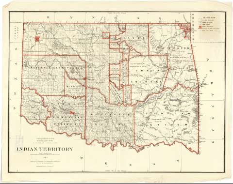
Indian Territory


Section: Maps, plans and nautical charts
Uniform title: OKLAHOMA (Estados Unidos). Mapas generales. 1:760320 (1883)
Title: Indian Territory / Department of the Interior, General Land Office, N.C. Mc. Farland, Commissioner ; compiled from the official Records of the general Land Office and other sources G.P. Strum, Principal Draughtsman G.L.O.
Material or type of resouce Area: Escala [1:760320 ; proy. cónica equidistante] (O 100°00'--O 94°26'/ N 37°00'--N 33°35')
Publication: N.Y. [i.e. New York] : Photo lith print. by Julius Bien & Co. 139 Duane St., 1883
Physical description: 1 mapa : col. ; 61 x 83 cm
Content type: Imagen cartográfica
Media type: computadora
Carrier type: recurso en línea
Notes: Comprende el actual estado de Oklahoma y una pequeña parte del extremo noroccidental de Texas
Escala nominal de 12 millas por pulgada y gráfica de 50 millas [= 10'8 cm]. Coordenadas también referidas al meridiano de Washington (O 23°00'--O 17°25'). Red geográfica de 1° en 1°
Orografía por normales
Señala los límites de los territorios ocupados por las diversas tribus indias, especificándose la fecha y la referencia legal de los tratados por los cuales fueron establecidos
Sobre el mapa aparece trazada una retícula, marcadas con números arábigos tanto las abcisas como las ordenadas, que parece ser un sistema de localización de aquellos municipios sobre los que se han realizado mediciones catastrales
Tabla de los signos convencionales empleados para indicar : núcleos de población, destacándose la capital de cada una de las naciones indias, reservas militares y caminos
Impreso en verde y rojo
Materia / lugar / evento: Poblaciones indígenas
Mapas generales
Tratados
Campamentos militares
1883
Other authors: McFarland, N. C
Bien, Julius, 1826-1909
Strum, G.P
Estados Unidos. Department of the Interior
Estados Unidos. General Land Office
UDC: 912:397:341.241:355.71(766)"1883"
766
Type of publication:
 Maps
Maps
Rights:
Préstamo:
 Disponible
