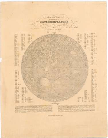
General - Karte der sichtbaren seite der Mondoberflaeche...


 Maps, plans and nautical charts
General - Karte der sichtbaren seite der Mondoberflaeche : zugleich als ubersichts - Blatt zur grossern Mond -... (1837)
Maps, plans and nautical charts
General - Karte der sichtbaren seite der Mondoberflaeche : zugleich als ubersichts - Blatt zur grossern Mond -... (1837)
 Disponible Holdings
 Section: Maps, plans and nautical charts
Uniform title: LUNA (Satélite). Mapas celestes. 5° por 1 cm (1837)
Title: General - Karte der sichtbaren seite der Mondoberflaeche : zugleich als ubersichts - Blatt zur grossern Mond - Karte van with Beer un Joh. Heinr. Madler / gezeichnet von J.H. Madler ; gestochen von E. Leidenfrost
Material or type of resouce Area: Escala 5° por 1 cm ; [proyec. ortográfica meridiana]
Publication: Berlin : Simon Schropp et Comp., 1837
Physical description: 1 carta celeste ; 1 hemisferio 32,4 cm diáur., en h. de 64,9x50,7 cm
Content type: Imagen cartográfica
Media type: computadora
Carrier type: recurso en línea
Notes: Relieve representado por sombreado
Relación de los principales crateres y mares de la Luna indicados por clave numérica
Texto explicativo de la carta celeste
Materia / lugar / evento: Mapas celestes
1837
Other authors: Maedler, J.H
Leidenfrost, E
Simon Schropp'sche Hof-Landkartenhandlung
UDC: 912:[523/524](158)'1837'
158
Type of publication:
Maps
Rights:
Préstamo:
Disponible
