Fuerte de Sta. Bárbara ; Perfiles del antiguo fuerte de...


 Maps, plans and nautical charts
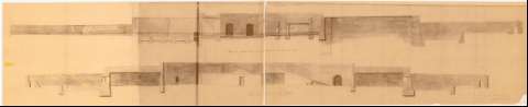
Fuerte de Sta. Bárbara ; Perfiles del antiguo fuerte de Sta. Bárbara únicos datos que se conservan (189-?)
Maps, plans and nautical charts
Fuerte de Sta. Bárbara ; Perfiles del antiguo fuerte de Sta. Bárbara únicos datos que se conservan (189-?)
 Disponible Holdings
 Section: Maps, plans and nautical charts
Uniform title: LA LÍNEA DE LA CONCEPCIÓN (Cádiz). Fuerte de Santa Bárbara. Fuertes. Escala indeterminada (189-)
Title: Fuerte de Sta. Bárbara ; Perfiles del antiguo fuerte de Sta. Bárbara únicos datos que se conservan / dibujado por el Ob. de 2 Mario González
Material or type of resouce Area: Escala indeterminada
Publication: [Madrid : s.n., 189-?]
Physical description: 2 perfiles en 1 h. : montado sobre tela ; 31,5 x 156,5 cm, pleg. en 31,5 x 79 cm
Notes: "V.B." el Tte. Coronel Jefe de la Com. Federico Magallanes
Copia en ozalid
Materia / lugar / evento: Fortificaciones
Fuertes
S.XIX
Cádiz (Provincia)
Andalucía
Other authors: Gonzalez, Mario
UDC: (460.355 La Línea de la Concepción)
Type of publication:
Maps
Rights:
Préstamo:
Disponible
