France en 6 feuilles


Section: Maps, plans and nautical charts
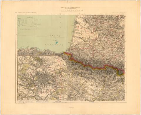
Uniform title: Francia. Mapas catastrales (1896). 1:1000000
Title: France en 6 feuilles / par F. Prudent ; Dessiné le trait et la lettre par Weinreb ; gravé le trait et la topographie par E. Delaune, la lettre par Er. Dumas - Vorzet ; Imprimé en taille donce par Dufrenoy
Material or type of resouce Area: Escala 1:1000000 ; [proyec. cónica]
Publication: [Paris] : Publié par la Librairie Hachette & Compte., 1896-1897
Physical description: 1 mapa en 6 h. : col. ; h. de 43x53,7 cm
Notes: Comprende el sur de Francia y el noreste de España
Pertenece al 'Atlas Universel par Vivien de Saint - Martin & Fr. Schrader'
Coordenadas referidas al meridiano de Paris. Red geográfica de 1° en 1°
Relieve representado por normales
Tabla de signos convencionales para indicar núcleos de población de distinta categoría, limites administrativos, rutas y canales de agua
Indica los limites administrativos en amarillo, carmin, verde y rojo
Inserta : Environs de Paris. - Escala 1:200000
Incompleto, sólo se dispone de las hojas V y VI
FRN
Materia / lugar / evento: Mapas generales
Divisiones administrativas
1897
España
Other authors: Prudent, F (Ferdinand), 1835-1915
Dumas-Vorzet, Edmond, 1841-1885
Dufrenoy, E
Delaune, E
Weinreb
Hachette (Firma)
UDC: 912(44-21-5+460-18)'1896/1897'
(460-18)
Type of publication:
 Maps
Maps
Rights:
Préstamo:
 Disponible
