Europe : Divisée en ses Différens Etats suivant Les...


 Maps, plans and nautical charts
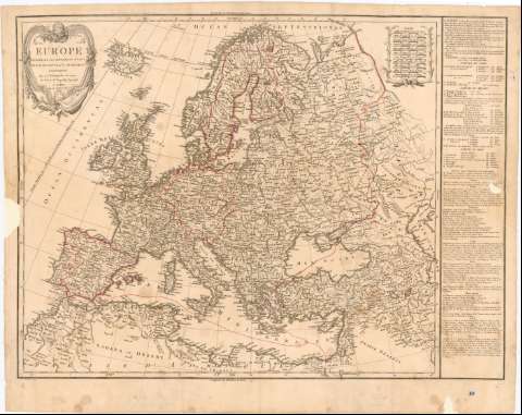
Europe : Divisée en ses Différens Etats suivant Les Nouveaux Changemeus Politiques (1809)
Maps, plans and nautical charts
Europe : Divisée en ses Différens Etats suivant Les Nouveaux Changemeus Politiques (1809)
 Disponible Holdings
 Section: Maps, plans and nautical charts
Uniform title: Europa. Mapas generales. 1:9000000 (1809)
Title: Europe : Divisée en ses Différens Etats suivant Les Nouveaux Changemeus Politiques / Par C.F. Delamarche, Successeur de Robert de Vaugondy Géographe ; Barriere Sculp.
Material or type of resouce Area: Escala [ca. 1:9000000], 60 Milles Communs d'Allemagne de 15 au Degre [= 8 cm] ; [proyec. Estereografica]
Publication: A Paris : C.F. Delamarche Rue du Jardinet N 13, 1809
Physical description: 1 mapa : col. ; 49x66 cm en h. de 56x70 cm
Content type: Imagen cartográfica
Media type: computadora
Carrier type: recurso en línea
Notes: Escalas graficas de 20 Leguas Marinas de 20 grado, 60 Millas de Turquia de 60 al grado, 40 Millas se Hungria, 40 Millas de Italia de 60 al grado etc. Coordenadas referidas al meridiano de Hierro (O355°0'-E75°0'/N70°0'-N29°20') Referidas al Meridiano de París (O10°0'-E45°0'/N70°0'-N29°20') Red geografica de 5° en 5°
Relieve de perfil
Nota sobre la división de Europa en países. Sus Golfos, Cabos, rios, montañas y lagos.
Indica divisiones administrativas y fronteras coloreadas a mano en marron
Titulo enmarcado en cartela barroca con la bola del mundo
Procede de la 'Colección Rico y Sinobas' N 10
Other authors: Barrière, François, 1786-1868
Delamarche, Charles François
UDC: 912:341.222(4)'1809'
(6-17)
Type of publication:
Maps
Rights:
Préstamo:
Disponible
