Disposition of the Allies for the Attack of the Enemy's...


 Maps, plans and nautical charts
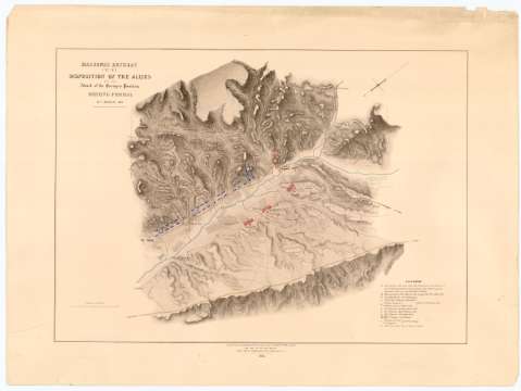
Disposition of the Allies for the Attack of the Enemy's Position, beyond Pombal, 12th. March 1811 (1868)
Maps, plans and nautical charts
Disposition of the Allies for the Attack of the Enemy's Position, beyond Pombal, 12th. March 1811 (1868)
 Disponible Holdings
 Section: Maps, plans and nautical charts
Title: Disposition of the Allies for the Attack of the Enemy's Position, beyond Pombal, 12th. March 1811 / Coll. Sir H. James... Director
Material or type of resouce Area: Escala [ca. 1:50000], 2 Miles [= 6,4 cm]
Publication: London : Lithoa. from the Original Drawing in the Qr. Mr. Genls. Office at the Topl. Dept. of the War Office, 1868
Physical description: 1 mapa : col. ; 39,2x55 cm en h. de 50,9x68,5 cm
Content type: Imagen cartográfica
Media type: computadora
Carrier type: recurso en línea
Notes: Pertenece al 'Massena's Retreat' ; N 2
Orientado con flecha en cuadrante
Relieve representado por normales
Relación de las principales prosiciones, divisiones y cuerpos de los ejércitos indicados por clave alfabética
Indica vegetación, caminos y las posiciones de los ejércitos por clave cromática
Materia / lugar / evento: Guerras de independencia
Operaciones bélicas
Estrategia militar
1811
Pombal
Other authors: James, H Sir
Gran Bretaña. War Office
UDC: 912:[355.4:355.43](469-328 Beira Litoral)'1811'
(469 Pombal)
Type of publication:
Maps
Rights:
Préstamo:
Disponible
