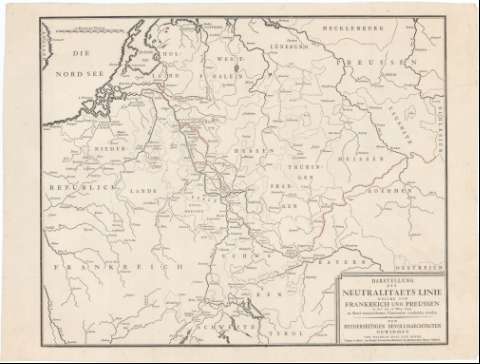
Darstellung der Neutralitataets Linie Welche von...


 Maps, plans and nautical charts
Darstellung der Neutralitataets Linie Welche von Frankreich und Preussen un der am 17 May 1795 zu Basef...
Maps, plans and nautical charts
Darstellung der Neutralitataets Linie Welche von Frankreich und Preussen un der am 17 May 1795 zu Basef...
 Disponible Holdings
 Section: Maps, plans and nautical charts
Uniform title: Europa. Central. Fronteras. 1:400000 (1795)
Title: Darstellung der Neutralitataets Linie Welche von Frankreich und Preussen un der am 17 May 1795 zu Basef unterrzeichpet en Convention verabredet Worden : den Beryderseitigen Bevollmaechtigten Gewidmet
Material or type of resouce Area: Escala [ca. 1:400000], 20 Deutsche Meilen [= 7,2 cm]
Publication: Basel [Basilea] : Wilhelm Haas dem Sohne (Typogr. ... der Konigl Preussischen Kademie der Mechanischen Kunste Mitghed), 1795)
Physical description: 1 mapa ; 35x43,4 cm en h. de 38,3x51 cm
Content type: Imagen cartográfica
Media type: computadora
Carrier type: recurso en línea
Notes: Comprende el N.E. de Francia, N. de Suiza, Belgica y Alemania
Indica divisiones administrativas
Materia / lugar / evento: Fronteras
Tratados de paz
Topónimos antiguos
1795
Francia
Bélgica
Alemania
Prusia
Suiza
Other authors: Haas, Wilhelm
Alemania. Koniglch Preussischen Akademie der Mechanischen Klinste Mitghed
UDC: 912:341.222]:341.241(4-191.2)'1795'
Type of publication:
Maps
Rights:
Préstamo:
Disponible
