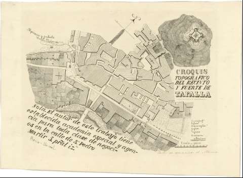
Croquis topográfico del recinto y fuerte de Tafalla


 Disponible Holdings
 Section: Maps, plans and nautical charts
Uniform title: TAFALLA (Navarra). Planos de población. 1:2600 (1880?)
Title: Croquis topográfico del recinto y fuerte de Tafalla / Propietario y grabador Emilio Valverde
Material or type of resouce Area: Escala [ca. 1:2600]
Publication: [Madrid? : [Editor no identificado], 1880?]
Physical description: 1 plan. : montado sobre tela ; 23 x 32 cm
Content type: Imagen cartográfica
Media type: computadora
Carrier type: recurso en línea
Notes: Firmado y rubricado por el autor
Fecha tomada del catálogo del SGE: "Región Vasco-Navarra. Provincia de Navarra. Siglos XVII a XIX". 1969, p. 509
Escala gráfica de 158 pasos [= 4,1 cm]. Orientado con flecha
Orografía por normales
Relación de las casas fortificadas, fuertes, muros, plazas, puente y una carretera en dirección a Pamplona, indicadas por clave numérica
En nota : "El autor de este trabajo tiene establecida academia especial y agencia para toda clase de negocios en la calle de Sn Pedro Mártir 5, pral. rza. Precio -Un real"
En otra nota manuscrita: "Centro de operaciones de Marines"
Materia / lugar / evento: Planos de población
Fortificaciones
1880
Navarra (Comunidad Autónoma)
Other authors: Valverde y Álvarez, Emilio, 1848-1894
UDC: 912:[314(084.3)]:623.1(465.111.4)"1880"
465.111.4 Tafalla
Type of publication:
 Maps
Maps
Rights:
Préstamo:
Disponible
