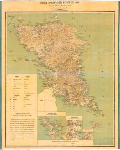
Cróquis Topográfico del distrito de Sámar [mapa] =...


 Maps, plans and nautical charts
Cróquis Topográfico del distrito de Sámar [mapa] = Topographical sketch ofthe District of Sámar (1898?)
Maps, plans and nautical charts
Cróquis Topográfico del distrito de Sámar [mapa] = Topographical sketch ofthe District of Sámar (1898?)
 Disponible Holdings
 Section: Maps, plans and nautical charts
Uniform title: SAMAR (Filipinas). (Isla). Mapas generales. 1898?. 1:400000
Title: Cróquis Topográfico del distrito de Sámar [mapa] = Topographical sketch ofthe District of Sámar / por Enrique d'Almonte y Muriel
Material or type of resouce Area: Escala 1:400000
Publication: [[Lugar de publicación no identificado] : [Editor no identificado], 1898?]
Physical description: 1 mapa : col., montado en tela ; 67 x 54 cm
Content type: Imagen cartográfica
Media type: computadora
Carrier type: recurso en línea
Notes: En nota : "Este trabajo se terminó en el mes de Enero de 1898"
Coordenadas referidas al meridiano de Madrid (E 128°00'--E 129°30'/N 12°30'--N 10°30'). Red geográfica de 30' en 30'
Representación del relieve por sombreado y puntos acotados. Veriles y bajos
Nota informativa sobre las fuentes utilizadas para la realización del mapa
Tabla de signos convencionales para indicar las cabeceras de distrito, pueblos, carreteras, caminos, etc. y abreviaturas para las islas, ríos, montes, etc
Impreso a varias tintas. Barnizado
Inserta "Islas Daram y Buad = Daram and Buad Islands".- Escala 1:200000. "Costa oriental de Samar : Inmediaciones Súlat y S. Julian = Environs ofSúlat and San Julián".- Escala 1:200000. "Inmediaciones de Lanang = Environs of Lanang".- Escala 1:200000
Materia / lugar / evento: Mapas generales
Other authors: Almonte, Enrique de, 1858-1917
UDC: 912(914:22)"1898"
914:22 Samar
Type of publication:
Maps
Rights:
Préstamo:
Disponible
