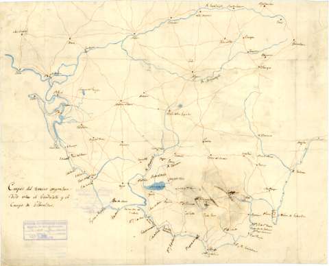
Croquis del Terreno comprehendido entre el Guadalete y el...


 Maps, plans and nautical charts
Croquis del Terreno comprehendido entre el Guadalete y el Campo de Gibraltar (1810)
Maps, plans and nautical charts
Croquis del Terreno comprehendido entre el Guadalete y el Campo de Gibraltar (1810)
 Disponible Holdings
 Section: Maps, plans and nautical charts
Uniform title: Cádiz (Provincia). Mapas generales. 1:250.000 (1810)
Title: Croquis del Terreno comprehendido entre el Guadalete y el Campo de Gibraltar
Material or type of resouce Area: Escala [ca. 1:250.000]
Publication: [1810]
Physical description: 1 mapa : ms., col., montado sobre tela ; 38,4 x 47,4 cm
Notes: Manuscrito a plumilla en tinta negra y coloreado a la acuarela en azul, siena y carmín
Materia / lugar / evento: Mapas generales
Costas
Ríos
Guerras de independencia
1810
Algeciras
Guadalete (Río)
Cádiz (Provincia)
Andalucía
España
UDC: (460.355)
Type of publication:
Maps
Rights:
Archivo Cartográfico de Estudios Geográficos del Centro Geográfico del Ejército
Collection: PCGE — Location: AR — Call number: Ar.G-T.8-C.1-550 — Código de barras: 2211317
Préstamo:
Disponible

© Ministerio de Defensa de España
P. de la Castellana, 109 28071 Madrid.
Tlf: (34) 91 395 50 00
Email: patrimonio.cultural@oc.mde.es