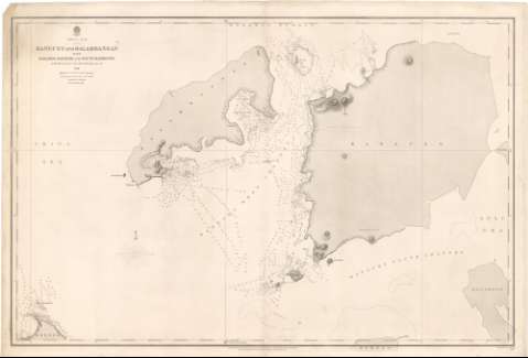
China sea, Banguey and Balambangan With Barabok Barabok...


 Maps, plans and nautical charts
China sea, Banguey and Balambangan With Barabok Barabok and South Harbours (1860)
Maps, plans and nautical charts
China sea, Banguey and Balambangan With Barabok Barabok and South Harbours (1860)
 Disponible Holdings
 Section: Maps, plans and nautical charts
Title: China sea, Banguey and Balambangan With Barabok Barabok and South Harbours / Surveyed by Captn. sir Edwd. Belcher R.N.C.B. ; Engraved by J. & C. Walker
Material or type of resouce Area: Escala [ca. 1:74000]
Publication: London : Published at the Admiralty 6th. Aug. 1860, under the Superintendence of Captn. Washington, R.N.F.R.S. Hydrographer, 1860 (London ? : Sold by J.D. Potter Agent for the Admiralty Charts 31 Poultry & 11 King Street Tower Hill)
Physical description: 1 carta náutica ; 68'7x50'8 cm
Content type: Imagen cartográfica
Media type: computadora
Carrier type: recurso en línea
Notes: Escala hallada a partir de un minuto de la latitud [= 2,5 cm]
Orientado con estrella y media lis en nudo de rumbos
Relieve representado por normales y sondas batimétricas en Brazas
Indica veriles y bajos
Sello de la Hydrographic Office
Other authors: Belcher, Edward
Washington
Potter, J.D
J. & C. Walker
UDC: 912:[551.46:551.42](91 Balambangan, isla)
91 Balambangan, isla
Type of publication:
Maps
Rights:
Préstamo:
Disponible
