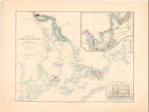
Chart of the Canton River with the entrances and islands...


 Maps, plans and nautical charts
Chart of the Canton River with the entrances and islands : compiled from original surveyed Pketches (184- ?)
Maps, plans and nautical charts
Chart of the Canton River with the entrances and islands : compiled from original surveyed Pketches (184- ?)
 Disponible Holdings
 Section: Maps, plans and nautical charts
Uniform title: SIKIANG (China) (Río). Cartas náuticas. 184. 1:350000 (1841)
Title: Chart of the Canton River with the entrances and islands : compiled from original surveyed Pketches / by James Wyld geographer to the queen
Edición: 3 ed.
Material or type of resouce Area: Escala [ca. 1:350000], 20 millas [= 10,6 cm] ; [proyec. Mercator] (E130°00'-E114°45'/N23°10'-N21°50')
Publication: London : published by James Wyld, Charing Cross East, [184- ?]
Physical description: 1 carta náutica : col. ; 42,4x55,5 cm en h. de 52,3x69,5 cm
Content type: Imagen cartográfica
Media type: computadora
Carrier type: recurso en línea
Notes: Presenta además mapa de situación
Red geográfica de 15' en 15'. Orientado con flecha en cuadrante
Indica veriles, bajos, fondeaderos y sondas batimétricas
Tabla de signos convencionales para indicar las posiciones chinas e inglesas
Inserta : Plan of the city of Canton. - Escala [ca. 1:30000]
Materia / lugar / evento: Cartas náuticas
Islas
Desembocaduras de ríos
1841
Other authors: Wyld, James, 1812-1887
UDC: 912:[551.46:551.42:556.54](282.05 Sikiang)(510)'1841'
282.05 Sikiang)(510
Type of publication:
Maps
Rights:
Préstamo:
Disponible
