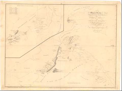
Chart of Felicia and Plan of the Island Balambangan, His


 Disponible Holdings
 Section: Maps, plans and nautical charts
Uniform title: BALAMBANGAN (Sabah) (Isla). Cartas náuticas. 1:93000 (1770)
Title: Chart of Felicia and Plan of the Island Balambangan, His / Is humbly presented By... Adalrymple ; Graduated & Engrav'd by B. Henry ; the Hills Etch'd by D. Lerperiere ; the Writing Engraved by W. Whitchurch, Bartholomew Lahe, Royal Exchange, London
Material or type of resouce Area: Escala [ca. 1:93000], 10 nautick miles [= 20 cm]
Publication: [London ?] : Published according to Act of Parliament by Alexander Dalrymple, Novr. 30, 1770
Physical description: 1 carta nautica ; 50'2x66'9 cm
Content type: Imagen cartográfica
Media type: computadora
Carrier type: recurso en línea
Notes: Dedicatoria : 'To His Majesty George the third, King of Great Britain & C.'
Relieve representado por normales
Relación de los principales accidentes geográficos indicados por clave alfabética
Other authors: Dalrymple, Alexander
Whitchurch, William
Lerpeniere, D
Henry, B
UDC: 912:[551.46:551.42](91 Balambaugau,islas)'1770'
91 Balambaugau,islas
Type of publication:
 Maps
Maps
Rights:
Préstamo:
Disponible
