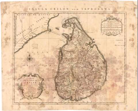
Carte de L'Isle de Ceylan


Section: Maps, plans and nautical charts
Uniform title: Sri Lanka. Cartas nauticas. 1:112.000 (174)
Title: Carte de L'Isle de Ceylan / Dressée sur les observations de Mrs. De L'Academie Royale Des Sciences par le Sr. De L'Isle
Material or type of resouce Area: Escala [ca. 1:112.000], 15 Lieves Communes d'Allemagne de 15 au degré [= 9,5 cm]
Publication: A Amsteldam : Chez Iean Covens et Corneille Mortier, [174- ?]
Physical description: 1 mapa ; 47x56 cm en h. de 54x66 cm
Content type: Imagen cartográfica
Media type: computadora
Carrier type: recurso en línea
Notes: 20 Leguas marinas de Francia e Inglaterra de 20 al grado [= 9,5 cm], 15 Leguas marinas de España de 17 al grado [= 9,5 cm]. Coordenadas referidas al parecer al meridiano de Paris (E95°20'-E100°50'/N10°15'-N6°15') Orientado con lis en rosa de 8 vientos
Relieve de perfil
Indica veriles, bajos fondeaderos y sondas batimetricas
Título enmarcado en cartela barroca con motivos vegetales
Procede de la 'Colección Rico y Sinobas '74'
Materia / lugar / evento: Cartas náuticas
Islas
Siglo XVIII
Other authors: Delisle, Guillaume
Covens & Mortier (Amsterdam)
UDC: 912:[551.46:551.42](548.7)'1740/1749'
548.7
Type of publication:
 Maps
Maps
Rights:
Préstamo:
 Disponible
