Carta topográfica de la línea militar de Irún a Hernani


 Disponible Holdings
 Section: Maps, plans and nautical charts
Title: Carta topográfica de la línea militar de Irún a Hernani
Material or type of resouce Area: Escala [ca. 1:17000]
Physical description: 1 mapa en 3 hoja : ms., col., papel vegetal ; en hoja de 40'5 x 62'4 cm o menor
Content type: Imagen cartográfica
Media type: computadora
Carrier type: recurso en línea
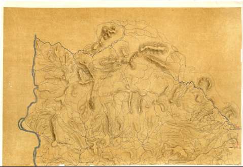
Notes: Documento incompleto que comprende parte del partido judicial de San Sebastián, representada en dos hojas la zona situada entre la costa y el río Bidasoa desde las poblaciones de Fuenterrabía e Irún hasta Alcibar, y en unatercera, sin continuidad con las anteriores, parte correspondiente a Oyarzun, no siendo posible precisar el número de hojas que faltan
Fecha tomada del catálogo del SGE: "Región Vasco-Navarra. Provincia de Guiiopúzcoa. Siglos XVI a XIX". 1969, p. 266
Escala gráfica de una legua de 20 al grado o de 2000 pies de burgos [= 32 cm]. Orientado con flecha
Orografía por sombreado y curvas de configuración
Señala la localización de los núcleos de población más significativos y caseríos
Iluminado en varios colores
Materia / lugar / evento: Mapas generales
1815
Guipúzcoa
País Vasco
UDC: 912(466.212)"1815"
466.212
Type of publication:
 Maps
Maps
Rights:
Préstamo:
Disponible
