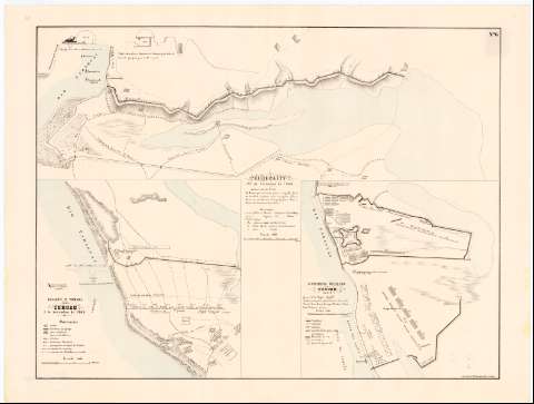
Assalto e tomada de Curuzu : 3 de Setembro de 1866


 Disponible Holdings
 Section: Maps, plans and nautical charts
Title: Assalto e tomada de Curuzu : 3 de Setembro de 1866 [Mapa]
Material or type of resouce Area: Escala 1:4000
Publication: Rio de Janeiro : Lith. Impl. de Ed. Rensburg,..., [1871]
Physical description: 1 map. : col. ; 31 x 32 cm, en h. de 61 x 80 cm, pleg. en 61 x 40
Notes: En : "Atlas historico da guerra do Paraguay". Hoja No. 6
Fecha de publicación tomada del atlas
Indica las distintas posiciones de las fuerzas que intervinieron en el asalto, la fortificación brasileña, la trinchera paraguaya, la línea de retirada del enemigo, etc.
La campaña fue dirigida por los generales brasileños Fontes y Albino
Inserta : "perfil sobre altura frotificaçao inimiga".- Escala 1:250
Acompañado de : "Curupaity : 22 de Sembre de 1866" y "Acampamento brazileiro em Curuzu : 1866-7"
Materia / lugar / evento: Operaciones bélicas
Estrategia militar
Fortificaciones
1871
Ñeembucú
Other authors: Lithografia Imperial de Ed. Rensburg (Río de Janeiro)
UDC: 912:355.43:623.1(892.49)"1871"
892.49
Type of publication:
 Maps
Maps
Préstamo:
Disponible
