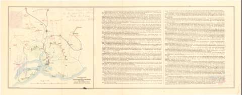
Approximate map of the Chinese position at Portarthur nov...
Section: Maps, plans and nautical charts
Uniform title: LUSHUN (China) (Liaoning). Ataques. 189. 1:50000 (1894)
Title: Approximate map of the Chinese position at Portarthur nov. 21st 1894 showing the japanese attack from sketches made November 20th to 30th, 1894 / tracing by C.M. Durand Mil. Inf. Div. A.G.O.
Material or type of resouce Area: Escala 1:50000
Publication: Washington D.C. : The Norris Peters Co., [189- ?]
Physical description: 1 mapa : col. ; 22,3x23,1 cm en h. de 25,7x65,3
Content type: Imagen cartográfica
Media type: computadora
Carrier type: recurso en línea
Notes: Escala gráfica de 5000 yardas [= 9,2 cm]. Orientado con flecha
Relieve representado por curvas de configuración
Indica las posiciones de ambos ejercitos por clave cromática
Texto explicativo de la defensa de Port - Arthur
En el ángulo superior derecho, anotaciones manuscritas a lápiz
Materia / lugar / evento: Ataque
Estrategia
Operaciones bélicas
Topónimos antiguos
1894
Port Arthur
Other authors: Durand, C.H
Norris Peters Company (Washington)
UDC: 912:[355.422:355.43:355.4](510 Lu-Shun)'1894'
510 Lu-Shun
Type of publication:
![]() Maps
Maps
Préstamo:
![]() Disponible
Disponible


